
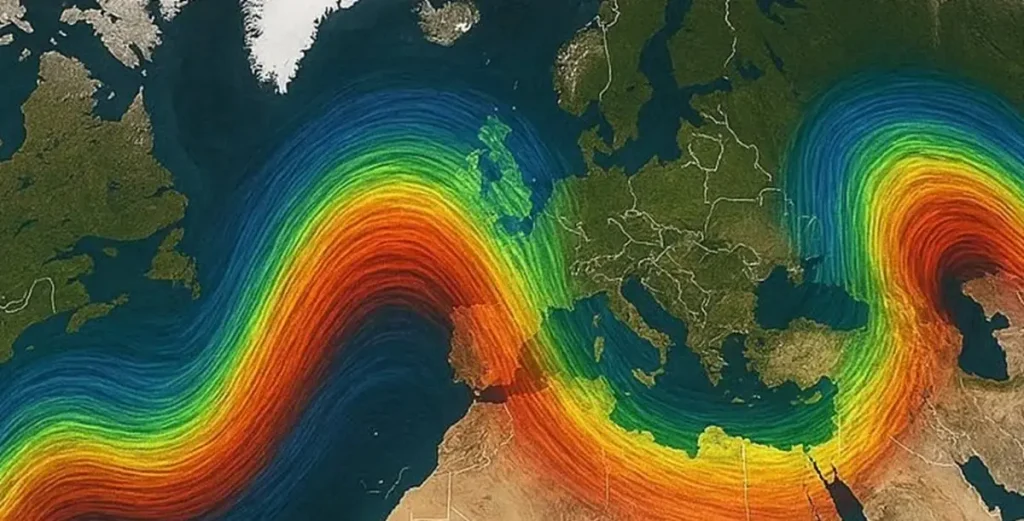
If you’ve ever wondered why British weather can be so unpredictable — one day sunshine, the next a storm — look up. High above our heads, racing across the sky at altitudes of 30,000 feet, sits the jet stream. This ribbon of fast-moving air doesn’t just fly over our heads; it decides what kind of weather we’ll have.
What Is the Jet Stream?
The jet stream is a narrow corridor of strong winds circling the globe, confined to the upper levels of the troposphere. In the Northern Hemisphere, there are two main branches: the polar jet stream, which separates cold polar air from milder temperate air, and the subtropical jet stream, marking the boundary between temperate and tropical air masses.
The polar jet is the one that matters most for UK weather. It typically flows from west to east, guided by the Coriolis effect and steered by the temperature contrast between the Arctic and the equator. The stronger this contrast, the faster the jet stream blows — speeds regularly exceed 100 mph, with gusts topping 250 mph during winter.
Think of it as a conveyor belt for weather systems. Low-pressure systems, fronts, and storms hitch a ride along the jet stream, moving at its pace and following its bends. Wherever the jet points, the weather follows.
How It Forms
The jet stream exists because of a fundamental imbalance: the equator receives far more solar energy than the poles. This creates a massive temperature gradient that tries to redistribute heat. But Earth’s rotation complicates the process.
As warm air rises at the equator and sinks at the poles, the Coriolis force deflects the air sideways, turning what would be a simple north-south circulation into an east-west flow. At the boundary between the cold polar cell and the warmer Ferrel cell — roughly around 60°N latitude — the air converges and accelerates, creating the jet stream.
Seasonal changes matter. In winter, the temperature difference between pole and equator is greatest, so the jet stream strengthens and dips further south. In summer, the contrast weakens, the jet slows, and it retreats northwards. This seasonal migration explains why winter tends to bring more storms and summer more stable weather.
Steering UK Weather
For the UK, the jet stream acts as both a traffic controller and a gatekeeper. Its position determines whether Atlantic depressions will slam into Britain or veer harmlessly north towards Iceland.
When the jet stream is positioned south of the UK:
- Atlantic lows follow the jet directly into the British Isles
- Wet, stormy weather dominates
- Unsettled conditions persist for days or weeks
When the jet stream sits north of the UK:
- High-pressure ridges build over the British Isles
- Calm, dry, and often warm conditions prevail
- Blocking patterns can develop, trapping weather systems in place
During winter 2023–24, the jet stream lingered south of Britain for weeks, directing successive low-pressure systems across the Atlantic. Somerset saw persistent rainfall, river levels rose, and flood warnings proliferated. Meanwhile, the summer of 2022 saw the jet stream park itself over Scandinavia, allowing high pressure to bake southern England through an unprecedented heatwave.
Meandering Patterns: Rossby Waves
The jet stream rarely flows in a straight line. Like a river in flood, it develops giant meanders called Rossby waves. These waves can stretch thousands of kilometres and persist for days or weeks.
When a wave dips south, it draws cold polar air towards lower latitudes — think cold snaps in spring. When it arches north, it carries warm subtropical air into Arctic regions — contributing to rapid warming in Greenland and the Faroes.
These meanders also influence the behaviour of weather fronts. A deep southward dip of the jet can lock a cold front in place, causing prolonged rainfall. A northward ridge might allow a warm front to stall over the UK, bringing days of drizzle without significant temperature change.
Sometimes the wave pattern breaks down entirely, forming “blocking highs” — large, stationary high-pressure systems that divert weather patterns around them. The summer 2018 drought occurred when a blocking high sat over Scandinavia for six weeks, preventing Atlantic depressions from reaching the UK.
Climate Change and the Jet Stream
Scientists are still debating how climate change will reshape the jet stream. The consensus suggests that as the Arctic warms faster than lower latitudes (a phenomenon called Arctic amplification), the temperature gradient driving the jet weakens.
A weaker gradient could mean:
- Slower jet stream speeds
- Larger, slower-moving meanders
- More frequent blocking patterns
Slower jets mean weather systems get “stuck” — a rainy week becomes a month-long deluge; a heatwave lingers instead of passing within days. Some researchers argue this mechanism explains recent extremes like the 2013–14 Somerset floods and the 2022 UK heatwaves.
Others caution that natural variability remains dominant, and attribution is complex. But the connection between Arctic warming and mid-latitude weather patterns is an active area of research, with implications for long-term forecasting.
Why It Matters for Forecasts
Meteorologists watch the jet stream closely because it’s the master regulator of short-to-medium-range weather. National Weather Services issue advisories when the jet is forecast to shift dramatically, knowing that a 500-kilometre displacement could mean sunshine instead of storms.
Advanced models simulate the jet stream’s three-dimensional structure, analysing wind speeds, temperatures, and pressure gradients at multiple atmospheric levels. Predicting its behaviour is one of the biggest challenges in modern meteorology — a slight error in positioning can cascade into days of wrong forecasts downstream.
For local weather stations like ours at Monkton Heathfield, the jet stream’s position tells us whether next week’s outlook leans towards dry high pressure or incoming frontal systems. It’s not a crystal ball, but it’s the closest we have to understanding what the next chapter of the weather story will say.
Jet Stream Around Monkton Heathfield
The Somerset Levels and surrounding hills create a unique microclimate where the jet stream’s influence manifests in subtle ways. When the jet is positioned south of Britain, the Bristol Channel funnels moisture inland, and the Tone valley sees enhanced rainfall. When it retreats north, high pressure builds over the Mendips, creating frost pockets in low-lying fields while the town of Taunton stays relatively milder.
Autumn 2020 provided a textbook example: a southward-dipping jet directed a succession of Atlantic lows straight at the South West. Rainfall totals at the West Monkton Cricket Ground station exceeded 200mm in six weeks, swamping the Levels and causing localized flooding along the River Tone. Conversely, July 2023 saw the jet shift north, leaving southern England under a high-pressure shield — our station recorded fifteen consecutive days with maximum temperatures exceeding 25°C.
Understanding the jet stream doesn’t just help forecasters — it helps us anticipate whether the next month will bring harvest-friendly dryness or spring planting delays. It’s the invisible thread connecting the Arctic ice cap to the crops in our fields.