
A Rose by Any Other Name
Ask a forecaster in Miami what hit Florida last autumn and they’ll say “hurricane”. Their counterpart in Tokyo will say “typhoon”. In the Bay of Bengal, it’s a “cyclone”. All three are describing exactly the same thing: a rotating storm system of tropical origin, with sustained winds of at least 74 mph (119 km/h) — the point at which we can speak of a genuine tropical cyclone rather than a weaker tropical storm or depression.
Why the different names? It’s simply history and geography. “Hurricane” comes from Huracán, the storm god of the indigenous Taíno people of the Caribbean, and it stuck to storms in the North Atlantic and northeast Pacific. “Typhoon” is used in the northwest Pacific and possibly blends the Chinese tai fung (“great wind”) with the Greek typhon. “Cyclone” — coined in the 1840s by the East India Company’s meteorologist Henry Piddington, from the Greek kyklos meaning “circle” — prevails in the Indian Ocean and South Pacific. The World Meteorological Organization referees the system: whichever regional name applies depends entirely on the basin in which the storm is born, not on any difference in its behaviour or power.
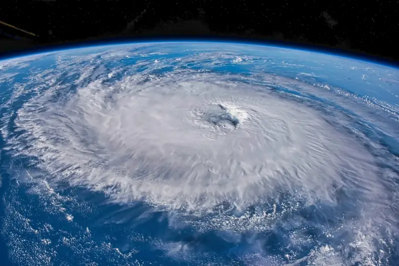
Building the Perfect Storm
A tropical cyclone needs a very particular recipe. First, warm sea water — generally at least 26.5°C down to a depth of about 50 metres — which supplies the heat and moisture that fuel the storm like a giant steam engine. Second, atmospheric moisture: humid middle layers that keep evaporation rising rather than drying out. Third, light winds aloft: strong wind shear tears a young storm apart before it can organise itself. Fourth, distance from the equator — typically at least 5° of latitude — so the Earth’s rotation (the Coriolis effect) can start the system spinning.
When all four ingredients come together, thunderstorms cluster over the warm ocean and begin to rotate. Warm, moist air rises, condenses, releases latent heat, warms the core further, and pulls in more air at the surface — a feedback loop meteorologists call cyclogenesis. The storm’s signature is its eye: a calm, sometimes eerily clear centre perhaps 20–50 km wide, surrounded by the eyewall, the ring of the most violent winds and torrential rain on the planet. In the Northern Hemisphere the system spins anticlockwise; south of the equator, clockwise — a handy party trick if you’re ever handed a satellite image.
The strongest hurricanes, like Typhoon Haiyan (2013) or Hurricane Allen (1980), have sustained winds exceeding 300 km/h. They rank on the Saffir-Simpson scale from Category 1 (74–95 mph) to Category 5 (157 mph or greater) — though rainfall and storm surge, not wind alone, are usually what kill.
Why They Matter in Monkton Heathfield
Here’s the connection to home. The Atlantic hurricane season runs from June to November, and most storms stay well to the west of us. But some recurve north-eastwards across the ocean, and when they do, they undergo what meteorologists call extratropical transition: they collide with our cooler seas and westerly jet stream, lose their pure tropical structure, and are reborn as ferocious mid-latitude depressions. We call the result an ex-hurricane.
These remnants can pack a serious punch. The Great Storm of October 1987 — which flattened an estimated 15 million trees across southern England — was associated with the remnants of a former hurricane interacting with a rapidly deepening Atlantic depression. Michael Fish’s infamous evening broadcast aside, few in Somerset who lived through it will have forgotten waking to blocked roads and a very different skyline.
Because ex-hurricanes arrive most often in September and October, it’s precisely now that they deserve a watchful eye in our part of the world. An ex-hurricane swinging across the Atlantic typically delivers heavy rain and gusty winds to the Southwest, occasionally strong enough to close roads — as heavy snow did here some years back, though that’s a winter story for another post.
Reading the Signs
For the curious observer, our Today page offers live wind speed, wind direction and rainfall readings updated every five minutes — precisely the instruments you’d want to glance at when an Atlantic storm of any pedigree rolls towards Somerset. The next time a forecaster mentions “the remnants of Hurricane So-and-so”, you’ll know exactly what’s headed our way, and what name it earned — and lost — crossing the ocean.
After all, all weather is local.